

As a recognised player in BIM infrastructure, FUTURMAP is supporting the SNCF in their national project to make all of its existing assets accessible to people with reduced mobility.
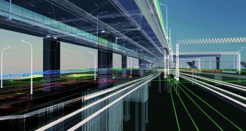
Several stations have therefore been modelled in 3D from 2D plans (DOE) as well as additional laser scanner surveys (LiDAR) with a level of detail (LOD 300) allowing a precise representation of all railway infrastructures and equipment (platforms, rails, catenaries, signaling, etc.) as well as underground networks.
To meet the needs and requirements of SCNF Réseau, specific design methods have been implemented. A Dynamo script has been specially developed to be able to model the railway track under Revit and parametric families have been created to allow a faithful representation of the catenary lines and posts, for semi-automatic extraction of assembly books.
FUTURMAP, Dpt CityMap, Coline THOURY - coline@futurmap.com
Other news

Fully custom data processing pipelines
Build custom tools for processing reality data with Pointscene’s new API
Allplan Bridge 2022: The evolution of precast bridge modelin...
Discover a dedicated modeling solution to generate accurate geometry easily and quickly


BIM Infra, a quality approach according to setec
The benefits of BIM Infrastructure are numerous. For a long time, BIM Infrastructure has r...

Infrakit’s owners’ view: schedule, costs and quality
The work environment for which Infrakit was designed for is quite extensive and diverse. M...
